
Where are we getting these images?
All of the images we are currently using in Floating Forests come from the Landsat satellite program. The Landsat program is an incredible series of satellites managed jointly by NASA and USGS that has been collecting imagery of the earth almost continuously since the early 1970s! This first Landsat satellite was launched in 1972 and the most recent, Landsat 8, was launched in February 2013. For Floating Forests we are using data from Landsat 4, 5, 7 and 8. We aren’t using data from earlier Landsat missions because the coarser resolution of these earlier satellites makes identifying kelp even more difficult than it already is. We also are not using data from Landsat 6 because this sensor crashed into the Indian Ocean soon after it was launched.

Timeline of the Landsat program
My favorite Landsat sensor has to be Landsat 5. This satellite was launched in 1984 and had an expected life span of 3 years. But it kept chugging along for an incredible 29 years and was only recently decommissioned in June 2013, giving it the Guinness World Record for the “longest operating earth observation satellite”. The long-term nature of the Landsat program is what makes it special. This data allows us to peek back in time to see how the earth has responded to climate change, human land-use change, disturbances like forest fires, mudslides, earthquakes, volcanic activity, and many other processes. Landsat has been used to monitor crop and forest harvests, map geologic features, monitor coral reef health, explore for oil and gas, measure changes in glacial coverage, track oil spills, aid regional planning, and for many, many other applications including, of course, tracking changes in giant kelp forests!
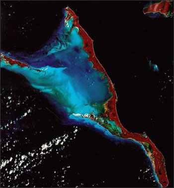
Landsat false-color infrared image of Long Island, Bahamas. Image from NASA.
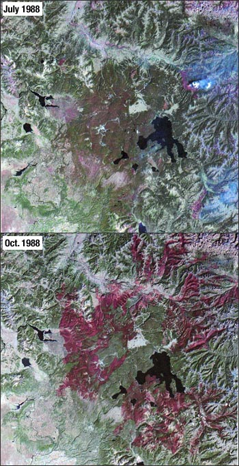
These images from July 22 and October 2, 1988 document the dramatic forest fires that occurred in and adjacent to Yellowstone National Park. Image from NASA
Best of all, since 2008 Landsat imagery has been available to the public at no cost. This has dramatically increased the ability of scientists to conduct the kind of long-term study that we are doing here at Floating Forests. It also has unleashed a flood of data: millions of scenes have already been collected and hundreds of new scenes are acquired each day by the Landsat satellites currently in orbit (Landsat 7 & 8). The challenge now is in developing ways to make sense of all of this data. Citizen science projects like Floating Forests are one exciting approach for tackling this problem, new automated processing algorithms are another.
Are you interested in performing your own analysis on Landsat imagery? Or would you like to make some art from these beautiful images? If so, it’s easy to download the data. Simply go to GLOVIS or EarthExplorer to get started. You can also watch a live feed of Landsat acquisition here.
2 responses to “Where are we getting these images?”
Trackbacks / Pingbacks
- - May 19, 2015
Leave a comment
Recent Comments
| jebyrnes on Does Citizen Science Consensus… | |
| padibby on Does Citizen Science Consensus… | |
| zuzayshish on Kelpy Consensus | |
| jebyrnes on Kelpy Consensus | |
| zuzayshish on Kelpy Consensus |

Very interesting. Where the current batch of data is from?
LikeLike