
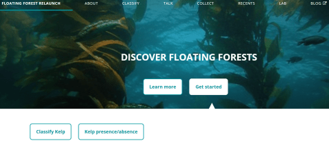
Welcome to Floating Forests 2.0!
If you are reading this post, it means the Floating Forests relaunch is live – thanks to all of your hard work we were able to get through over 20 years worth of data! Special thanks to the beta testers who gave us tons of feedback on the new site. We are busy on our end calibrating the results from the first round of data and it’s looking great. I don’t want to spill the beans on a future blog post, but working with this dataset has already led us down a new path with some unexpected collaborators!
As exciting as calibration models are, today’s main event is even better! Welcome to Floating Forests 2.0! We have been hard at work with Zooniverse to make your experience even better. In addition to a shiny new website, we’ll be taking you to a new part of the world – The Falkland Islands!
The Falkland Islands are an often overlooked ecological treasure. From land they appear a windswept grassland dominated by birds and insects, one of only a handful of places on Earth with no native trees. The coastal waters, however, are a different story altogether. You’ve probably guessed where this is going – kelp! Lots of kelp! The expansive kelp forests ringing the islands more than make up for the lack of terrestrial trees. Kelp forests around the world are a haven for wildlife, and these are no different. They are an irreplaceable resource for elephant seals, fur seals, sealions, multiple penguin species, two types of dolphins, and a huge number of fish and invertebrates. A recent report1 has listed lack of awareness and information as one of the biggest threat to the Falkland Islands’ marine biodiversity, so lets generate data and get aware!
Before you dive in, lets take a quick tour of the new website – if you’re familiar with our old site you’ll already know the drill, but some things have been moved around!
As you can see, there are two buttons at the bottom. “Classify Kelp” brings you to our shiny new version of the kelp tracing you all know and love. “Kelp presence/absence” you to a new feature- a simplified, mobile friendly task that can be done quickly and easily! This allows anyone who wants to check out the project to do so even if they don’t have access to a full computer. On the research side of things it allows us to squeeze every last drop of data out of these satellite images. To make a long story short, images from different satellites are different, and these differences make it somewhat difficult to automate a filter that boots out bad images. Just like with kelp classifications, our brains are much more useful here than computers. Once enough people have tagged an image as “kelp”, into the main workflow it goes to be classified!
Across the top, you will see a number of headings.
About: Learn about kelp, the project, and the team behind the research!
Classify: Get right to the action and start classifying kelp.
Talk: This links to our talk forum where you can discuss particular images, ask science questions, get technical help, and more! We will be very active here, so don’t hesitate to post!
Collect: More on this later, but this is where collections of images are found.
Recents: Link to your most recent classifications.
Blog: Direct link to the blog you are currently reading.
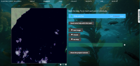
The classification should feel pretty familiar. The field guide tab on the far right has been overhauled and contains many examples of phenomena you could find in these images – refer to it often! It is constantly being updated, and if you have a suggestions for additions, let us know in talk!
Beneath the image are three buttons.

From the left:
Metadata: Click this to view metadata (location, time/date, satellite number), as well as a link to the image on google maps.
Favorite: Click this to add the image to your favorites, allowing you to quickly find it again.
Collect: Similar to adding an image to your favorites, you can add an image to a collection. This way we can collaboratively sort through images, keeping track of those that contain loads of kelp, cities, or any other identifiable feature.
Once you complete an image and have clicked the green “Done” button, you will see the following information:
Here you will see a summary of the number of patches you marked, as well as the blue “Talk” button. If you had any questions about the image, this button will create a discussion thread linked back to the image. Use this space to ask the science team any questions you might have about the image. Don’t be shy, we love to talk!
In addition to these front-end changes, there have been some under-the-hood updates as well that make it much easier for us to add images or collections and even create new workflows – stay tuned for future happenings with these features, but for now go check out the new site!
- Otley H. Falkland Islands Species Action Plan for Cetaceans 2008-2018.; 2008.
2 responses to “Welcome to Floating Forests 2.0!”
Leave a comment
Recent Comments
| jebyrnes on Does Citizen Science Consensus… | |
| padibby on Does Citizen Science Consensus… | |
| zuzayshish on Kelpy Consensus | |
| jebyrnes on Kelpy Consensus | |
| zuzayshish on Kelpy Consensus |

Will this project address the kelp forests dying along the California north coast. Without this food source for red abalone, their density and population has diminished significantly enough to cause the CA Commissioners of Fish and Game to close it completely to sport divers in 2018. We are very interested in promoting its healthy return- both the kelp and the red abalone.
LikeLike
We’re certainly hoping to get some of those areas in. The current dataset we’ve posted goes to 2012. In future rounds, we’ll update to 2018. We’re **very** curious to see what those dynamics look like.
LikeLike