
Hangout with the Science Team for Floating Forests!
Enjoying classifying kelp from space at Floating Forests? Want to know more about the science behind it? Want to know more about the SCIENTISTS behind it? Our research, how we got to where we are, and more? Have questions about the current Floating Forests platform?
Then come on over to Google + Tuesday the 16th at 2:30 pm ET (that’s tomorrow if you’re reading this on Monday) (or today if you’re reading this on Tuesday!) for a Hangout on Air to Meet the Floating Forests Science Team!
Hope to see you there – and let is know if you’ll be coming by signing up here. If you can’t make it, no worries! It’s a HOA, so, it will be posted to Youtube and the blog to live on in infamy!
Polish Floating Forests!
No, there’s no giant kelp in Poland (sorry) BUT a generous volunteer has translated our entire site into Polish! So check it out by going to the site, clicking the globe, and selecting Polski, and then ODKRYWAJ PŁYWAJĄCE LASY!

The Floating Forests Origin Story
Every great thing in this world has an origin story, right? Here’s ours.
Years ago, I was a postdoc at the Santa Barbara Coastal Long-Term Ecological Research Site (SBC LTER) working on the links between waves, kelp, and food webs. I had this problem. Big waves came through in the winter and removed a lot of kelp. Only, we only had divers going out in the summer, by which time kelp had often recovered, so I couldn’t estimate how much damage had been done.
Enter the brilliant Kyle Cavanaugh. As a grad student, he was pushing the limits on how we use satellite imagery for marine science. He’d devised a way to use imagery from Landsat, stretching back into the 1980s, to see giant kelp forest canopies from space. Better still, as every area around the earth was photographed about twice a month, this meant that he could see the forests I was analyzing right after storms hit them.
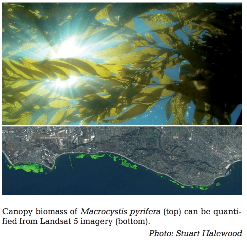
Fig 1 from Kyle’s Original work on kelp & Landsat
So, we struck up a collaboration to use the Landsat data he was collecting (paper here) to bring in the wave story. It was fantastic, and led to a wonderful collaborative paper.
And that could have been the end of it.
Except…there was this niggling thing. Landsat has images of the whole globe. And Giant Kelp isn’t just in California, but rather it’s found in areas all over the planet. Could we look at giant kelp across the planet?
As other members of the lab Kyle was in moved forward, they slowly expanded the dataset to include Baja, Northern California, and more. Why slow? Well, turns out, computers can’t just scan an image and tell you where the kelp is. Kelp looks like a lot of things in those pictures – like parts of the land, like clouds, like sea foam. But, to the human eye, it has some pretty distinct patterns in where it is and how it clumps together. The Siegel lab had setup a great pipeline of undergraduates who looked over the images, circled where kelp was, and then sent it back to grad students and computers to determine how much was there.
It took years just to get California. The globe seemed impossible.
A few years later, this came up while Kyle and I were seated in a room of amazing kelp forests scientists. We were at the National Center for Ecological Analysis and Synthesis for a working group on kelp forests and climate change. One of the tasks we had assigned ourselves was to build a global database of all of the kelp forest monitoring data out there. We found a number of wonderful datasets – some stretching into the 1970s, and one even into the 1950s. But all of these sets were limited to just a handful of sites. And there weren’t many of them.
What to do?
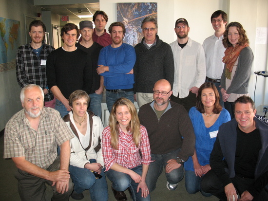
The NCEAS Kelp Forests and Climate Change working group
A few project members brought up Kyle’s Landsat data, but, expanding to the globe seemed daunting – until we realized that there might be a way to harness the power of the Crowd. I’d recently read Nielsen’s Reinventing Discovery where he talked about a project called Galaxy Zoo. In Galazy Zoo, astronomers had folk look at pictures of hundreds of thousands of galaxies and help them classify them into types. Along the way, citizen scientists not only had a good time, but even made some discoveries of types of celestial objects never before recorded.
Why not tap the power of folk interested in our oceans? Maybe we could provide images of coastlines that many people had never seen – to set them up as explorers of a potentially kelpy world, and help us get data along the way? People could see not only the kelp forests that might be lurking in their back yard, but discover features and forests in places we’d hardly ever been able to look before.
So, we emailed Zooniverse. It wasn’t their regular time to receive new submissions, but they wrote back right away, very excited. We put together a crackerjack team of scientists from our working group, and submitted an application to be a project, and as the next round swung around, they selected us to take part! We built a small science team from our larger network (who is still pretty active in the whole process!), began conversations with the Zooniverse team after going to their marvelous conference in Chicago, and we were off!
From that point on, it’s been smooth sailing to the great site you see now letting you sail the seas of Floating Forests (from space!)
Where are we getting these images?
All of the images we are currently using in Floating Forests come from the Landsat satellite program. The Landsat program is an incredible series of satellites managed jointly by NASA and USGS that has been collecting imagery of the earth almost continuously since the early 1970s! This first Landsat satellite was launched in 1972 and the most recent, Landsat 8, was launched in February 2013. For Floating Forests we are using data from Landsat 4, 5, 7 and 8. We aren’t using data from earlier Landsat missions because the coarser resolution of these earlier satellites makes identifying kelp even more difficult than it already is. We also are not using data from Landsat 6 because this sensor crashed into the Indian Ocean soon after it was launched.

Timeline of the Landsat program
My favorite Landsat sensor has to be Landsat 5. This satellite was launched in 1984 and had an expected life span of 3 years. But it kept chugging along for an incredible 29 years and was only recently decommissioned in June 2013, giving it the Guinness World Record for the “longest operating earth observation satellite”. The long-term nature of the Landsat program is what makes it special. This data allows us to peek back in time to see how the earth has responded to climate change, human land-use change, disturbances like forest fires, mudslides, earthquakes, volcanic activity, and many other processes. Landsat has been used to monitor crop and forest harvests, map geologic features, monitor coral reef health, explore for oil and gas, measure changes in glacial coverage, track oil spills, aid regional planning, and for many, many other applications including, of course, tracking changes in giant kelp forests!
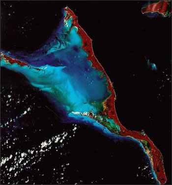
Landsat false-color infrared image of Long Island, Bahamas. Image from NASA.
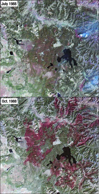
These images from July 22 and October 2, 1988 document the dramatic forest fires that occurred in and adjacent to Yellowstone National Park. Image from NASA
Best of all, since 2008 Landsat imagery has been available to the public at no cost. This has dramatically increased the ability of scientists to conduct the kind of long-term study that we are doing here at Floating Forests. It also has unleashed a flood of data: millions of scenes have already been collected and hundreds of new scenes are acquired each day by the Landsat satellites currently in orbit (Landsat 7 & 8). The challenge now is in developing ways to make sense of all of this data. Citizen science projects like Floating Forests are one exciting approach for tackling this problem, new automated processing algorithms are another.
Are you interested in performing your own analysis on Landsat imagery? Or would you like to make some art from these beautiful images? If so, it’s easy to download the data. Simply go to GLOVIS or EarthExplorer to get started. You can also watch a live feed of Landsat acquisition here.
Tips and Tricks for Error-free Classification!
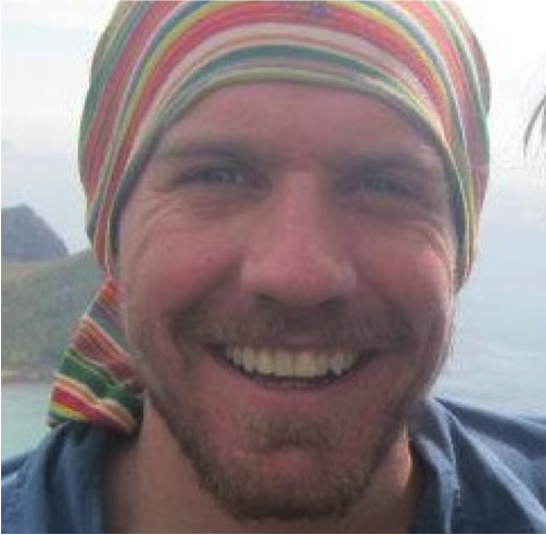
Hi! My name is Tom Bell and I am a scientist with Floating Forests. For the past 3 years, I have been working with Landsat images to estimate giant kelp biomass along the California and Baja California coasts. I have also had the opportunity to advise over 20 undergraduate analysts at the University of California, Santa Barbara to help process these images.
 One of the great things about Floating Forests is that image processing has been simplified so that users need very little training before they are off and running. However, this does not mean that every image will present a straightforward classification. Today, I want to take you through some common kelp classification errors and give you some tips on how to determine if that the questionable blob is kelp.
First lets start with the natural history of giant kelp and the general characteristics of the environment where it exists. Giant kelp is a coastal marine alga that forms dense stands in the Eastern Pacific, as well as off the coasts of South Africa, Australia, and New Zealand. Giant kelp anchors itself to the sea floor using a holdfast that tightly grips onto hard bottom, like a rocky reef. Kelp fronds can grow up to 45 meters long, but the maximum depth for an individual is about 30 meters, this is due to the limited sunlight where the newly settled microscopic kelp begin to grow. Waves are a major destructive force to kelp forests and can set its nearshore limit along rocky coastlines.
So now that we know the environment where kelp exists, we can use this information to better inform our kelp classification decisions. Let’s go through a few examples!
Waves
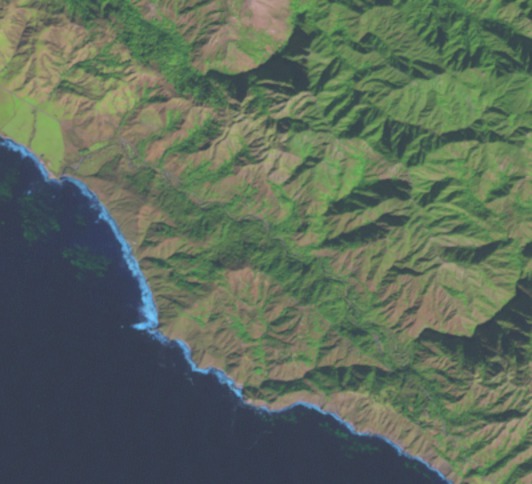
See these white (sometime blue) blobs along the coast? These are breaking waves. We know that breaking waves can be a major destructive force on a kelp forest, so you usually don’t see kelp where you see breaking waves. Remember, kelp forests will show up as green blobs. You can clearly see this large kelp forest growing just outside of the breaking waves.
Mudflats
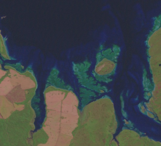
This sure does look like a dense kelp forest, bright green blobs right off the coast, but in fact these are tidal mudflats. This can be one of the most difficult issues you may face. Algae or seagrass growing on these mudflats is going to show a similar green color as kelp, but we know that giant kelp only grows on hard seafloor, like rocks and boulders.
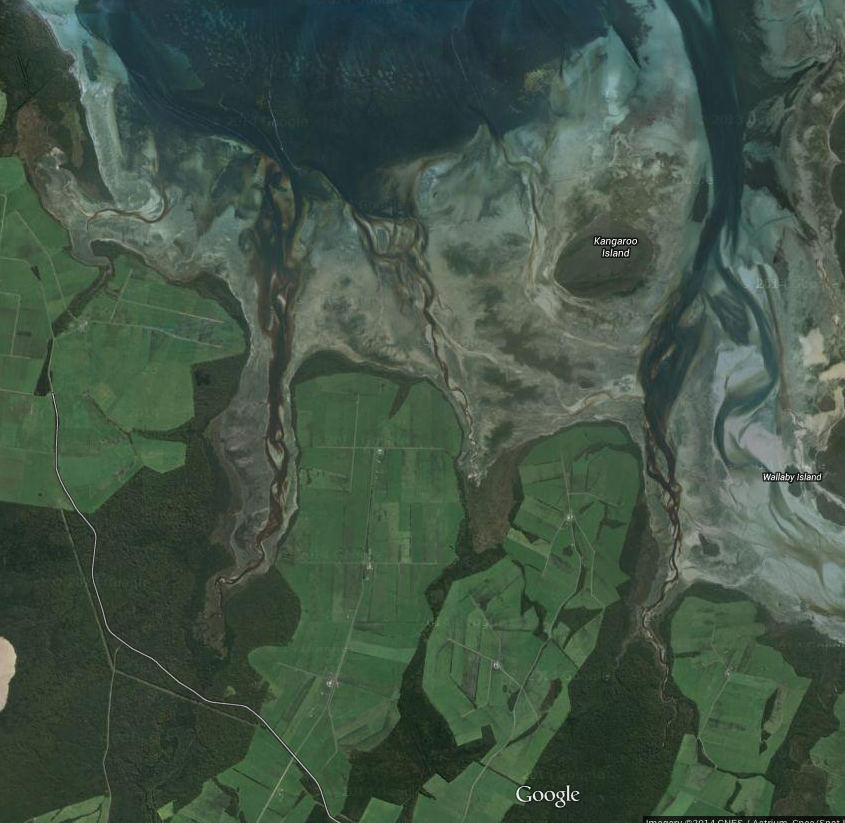
One way to make sure this is the right type of habitat for giant kelp is to use Google Maps or Google Earth. You can click on the coordinates above each image to automatically take you to a new page showing the approximate area of that image. Then, I like to copy just the coordinate numbers and paste them into the Google Maps search bar like, ‘38.557, -123.300’, this will place a pin on that exact location and show you a satellite image of the area with better spatial resolution.
Islands
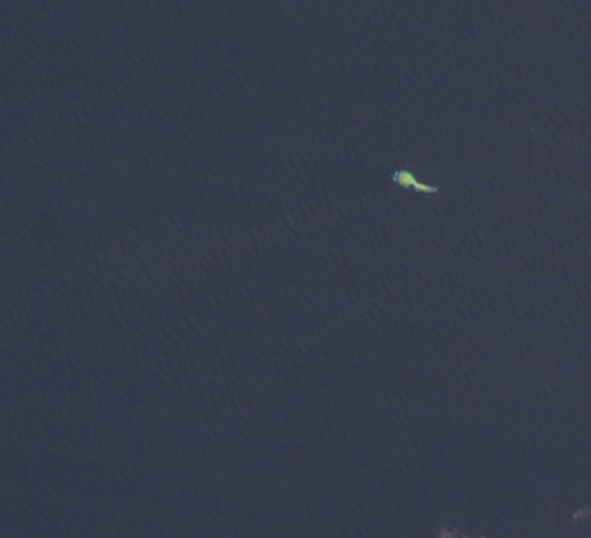
Small islands off the coast can sometimes appear to be dense kelp forests. Again, if you are unsure, I recommend using the Google Maps trick I explained above. You should then be able to confirm whether or not the green blob is kelp or a small rock/island.
Inland
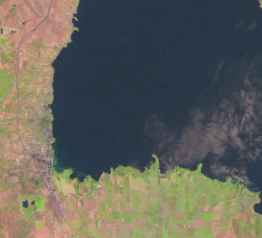
Giant kelp will never be growing in inland lakes or water bodies. This is a coastal marine species. If you see a green blob in a lake or some kind of inland river/delta/estuary/bay, it is probably something cool, but it is definitely not giant kelp. Again, if you are unsure, use the Google Maps link to see if the body of water you are looking at is coastal ocean or a lake/river/canal.
That is all for today! I am having a great time interacting with everyone on Zooniverse Talk, please keep the questions coming!
For Humpday: Kelp and German Metal
I have no words for how amazing this is. New project theme song?
Keybindings!
Looking for a quicker way to move through the non-kelp images? You can now type ‘n’ on your keyboard instead of clicking the “NEXT IMAGE” button. You can also use ‘c’ to toggle the cloud button. Happy hunting!
Out of Images? Not so Fast…

A number of you have been getting this message – either on login or when clicking through images.
Are we really done?
In short, no.
Basically, you all have been too amazing, and have gone through images far faster than we anticipated. We started with a number of Landsat scenes from California and Tasmania from 2012-2014 last Thursday. We thought it would take at least until Wednesday to get through that, and in that time, we’d have the rest of the California and Tasmania images chopped up and ready to go.
How wrong we were.
By Friday, the Zooniverse folk were scrambling to get the rest of the California and Tassie images into the system. And now you all are blowing through those, too! We had a beautiful artful roll-out plan for the entire globe that would stretch out over the course of the year. Clearly, we were wrong.
So, via Twitter we reached out to the NASA Landsat folk who put us in contact with the USGS Landsat folk who maintain the data, and we’re trying to see if we can fast track data acquisition. We’ll keep you posted.
But, now, we do have new data that the Zooniverse folk have put into the system (faster than anticipated because you all are awesome), and more on the way, so fear not! If you get the above message, it’s just a minor glitch that should go away shortly. Hit reload once or twice, and you should be all good!
The Beatles on Kelp and Citizen Science
You know you want to sing along…
Kelp! (Of Citizen science and satellites)
Kelp, I need somebody
Kelp, not just anybody
Kelp, you know I need folk to find, keeeeelp!
When I was younger (So much younger than) so much younger than today
(I never needed) I never needed satellites to see kelp in any way
(Now) But now those days are gone (These days are gone), divers only see so much
(I know I’ve found) Now I find I’ve changed my mind and downloaded more and more and more
Kelp me if you can, we’re peering down
And I do appreciate you looking ’round
Kelp us find algae while you sit upon the ground
Won’t you please, please kelp me
(Now) And now science has changed in oh so many ways
(The ivory tower) The ivory tower seems to vanish in the haze
(And) And every now (Every now and then) and then I feel so self-assured
(I know that I) I know that I can share my science like I’ve never done before
Kelp me if you can, we’re peering down
And I do appreciate you looking ’round
Kelp us find algae while you sit upon the ground
Won’t you please, please kelp me
When I was younger (So much younger than) so much younger than today
(I never needed) I never needed satellites to see kelp in any way
(Now) But now those days are gone (These days are gone), divers only see so much
(I know I’ve found) Now I find I’ve changed my mind and downloaded more and more and more
Kelp me if you can, we’re peering down
And I do appreciate you looking ’round
Kelp us find algae while you sit upon the ground
Won’t you please, please kelp me, kelp me, kelp me, ooh!
Update
All around awesome science blogger and fantastic scientist SciCurious has come up with some even better lyrics –
Kelp! They need some science
Kelp! Not just any science
Kelp! You know they need someone
To spot keeeeeelp!
When seas were younger so much younger than todaaaay,
We didn't know anything about kelp and all its ways.
But now those days are gone and we've got Landsat pictures puuure,
Now we find, a game in mind, to learn more and more and more.
Kelp us if you can we're feeling doooown,
And we've got thousands of pictures lying 'rouuuuund,
Kelp us spot our algae on the grooouuund.
Won't you pleeeease, please kelp me!

Recent Comments